Lawrence Rippon
New member
LEICESTER UK
- Aircraft Year
- 1977
- Aircraft Type
- 112B
- Reg Number
- G-BEPY
- Serial Number
- 524
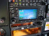
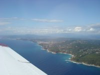
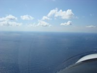
Took a trip from Gerona, Spain to Valencia, Spain last week via the Mediterranean. I realised that this was the first time I had ever had to zoom the GNS 430 screen out to 50 miles to find the shore. Due to the airspace around Barcelona, the part of the route furtherest from shore had to be flown at the lowest altitude, 2000'. Since getting home, some of my flying buddies think I am mad to route 200 miles across water. My response is that the aircraft doesn't know it is over water, so why should a breakdown be any more likely. I didn't like my chances in low cloud around the mountainous coast at low level in the VFR routes.
So, the question is, when the GPS screen is entirely blue, does it bother you? Do I have an unhealthy lack of respect for what is underneath me or do my flying buddies just need to get out more?
So, the question is, when the GPS screen is entirely blue, does it bother you? Do I have an unhealthy lack of respect for what is underneath me or do my flying buddies just need to get out more?